Geomatics, Integrated Sensors and 3D Imaging
Executive Summary
This technical publication explores the use of integrated sensor technologies for underground infrastructure inspections and geomatics applications. AquaCoustic’s approach combines CCTV, LiDAR, sonar, GPS, and additional sensing technologies to generate accurate 3D imaging and CAD-ready infrastructure data for sewer and pipeline assessments.
The paper discusses how integrated sensor surveys support improved pipe condition assessments, pipe meander mapping, hydraulic analysis, and infrastructure planning while reducing uncertainty associated with aging underground assets.
Publication Details
Publication: Northwest Trenchless Journal
Date: August 2023
Technical Overview
The publication outlines AquaCoustic’s integrated sensor survey methodology for underground infrastructure inspections. Multiple sensor technologies including CCTV, LiDAR, sonar, GPS, gas sensors, and robotic platforms are combined to produce detailed point-cloud and inspection datasets.
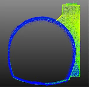
The paper also discusses processing workflows used to integrate laser and sonar data into accurate XYZ point clouds suitable for CAD and engineering analysis.
Key Contributions
Integration of laser and sonar data for enhanced underground pipe visualization
Accurate pipe geometry and deformation measurements
Pipe meander mapping and elevation tracking
CAD-ready point cloud generation for engineering workflows
Improved identification of sediment, erosion, and structural anomalies
Infrastructure Implications
Integrated sensor inspections provide municipalities, engineers, and infrastructure owners with more accurate underground asset information for maintenance planning, rehabilitation prioritization, and future infrastructure expansion projects.
The ability to combine multiple sensor technologies into a single inspection workflow also helps improve data quality while reducing uncertainty associated with aging infrastructure systems.